The African Union has formally endorsed a global campaign to promote a more accurate cartographic representation of Africa, arguing that the way the continent is depicted on traditional maps has long reinforced distorted power relations.
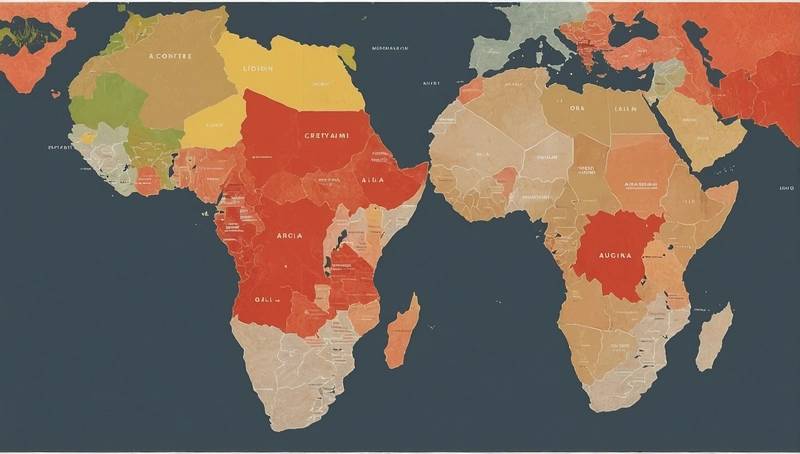
The initiative, known as “Correct The Map,” seeks to replace the widely used Mercator projection — first developed in the 16th century and popularised in the 19th — with alternatives such as the 2018 Equal Earth map, which better reflects the true proportions of the world’s landmasses.
The Mercator projection, designed for maritime navigation, enlarges regions near the poles, including Europe, North America and Greenland, while drastically shrinking Africa and South America.
For the African Union, this distortion has had far-reaching consequences, diminishing the continent’s visibility and perceived significance.
“Africa is the second largest continent on Earth, home to more than a billion people across 54 nations.
Yet in classrooms, in the media, and in policy debates, maps present it as much smaller than reality,” said Selma Malia Haddadi, vice-president of the African Union Commission. “This is not a mere detail because these representations influence education, the media and policies.”
Africa’s true size — 30.37 million square kilometres, large enough to contain the United States, China, India and most of Europe combined — rarely features prominently in global narratives. Campaigners argue this misrepresentation feeds into broader historical injustices rooted in colonialism.
The “Correct The Map” campaign, spearheaded by pan-African organisations Africa No Filter and Speak Up Africa, is calling on the United Nations, the World Bank, educators and media outlets to adopt the Equal Earth projection.
“Geography has a history. The misrepresentation of Africa on world maps is not just a cartographic error, it’s a narrative problem,” said Moky Makura, executive director of Africa No Filter.
“By reducing the size of Africa, we unconsciously minimize its importance. It’s time to take a stand.”
The African Union says adopting accurate maps is not only a matter of technical correction but also of reclaiming Africa’s rightful place in global discourse. “The world cannot afford to continue making decisions based on a 400-year-old distortion,” it declared. “It is time to correct the map and reframe the narrative.”